Sponsored by Dragon Adventure Motorcycle
Status: Currently Planning 2027. Dates, routes, and the full GPX set for The Dragon’s Loop are still being developed.
The Dragon’s Loop is an adventure and dual-sport motorcycle ride circling Roanoke, Virginia. It runs on state routes only (not a trail ride), with plenty of gravel, mountains, steep hills, switchbacks, and multiple creek crossings.
A few stretches are tough for large ADV bikes; some of those can be bypassed. The loop is aimed at street-legal 300cc thumpers and up. Heavier bikes take more skill here, and this is not a beginner ride — the gravel alone is more challenge than some riders can handle.
It travels through Botetourt, Craig, Rocky Mount, Eagle Rock, Bedford, Stewartsville, and more.
This one runs right in the adventure rider country of the Tail of the Dragon and Back of the Dragon realm — those two are legends of the pavement world, and The Dragon’s Loop aims to be their counterpart in the dirt and gravel.
Ride Notes / Difficulty
Rt 611 / Greyledge Rd has the rockiest section of the whole loop. There are also possible wet rocks or water crossings. The bypass is Rt 622 / Buffalo Rd.
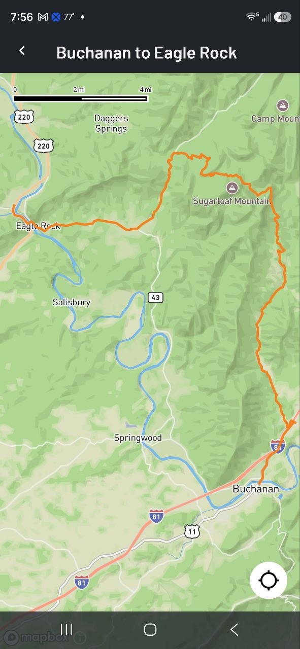
This is on the very first section out of Buchanan, and it can also be the wettest part of the route. The bypass runs just a few miles to the north and shows on the map, so riders on larger ADV bikes can skip the rocky, wet stretch entirely.
Download: The Dragon’s Loop Qualifier
The Dragon’s Loop Qualifier is one leg of the bigger ride: the I-81S Buchanan to Rt220N Eagle Rock Alternate. In my opinion, this leg also includes the hardest-to-ride section of the bigger Dragon’s Loop route, so it is a good way to judge whether the full loop suits you and your bike.
Get the Dragon_Loop_Qualifier GPX
I’m building a rider list for this route. I took my time mapping The Dragon’s Loop, and I appreciate knowing a little about who’s downloading the Qualifier. Leave your email and I’ll send you the GPX.
Note for this leg: Rt 611 / Greyledge Rd has the rockiest section of the whole loop, with possible wet rocks or water crossings. The bypass is Rt 622 / Buffalo Rd.
This GPX covers the Qualifier leg only — the complete Dragon’s Loop GPX set comes with the 2027 ride.
Email me for more information: info@dragonadv.com
The very first section from Buchanan has a hard rock section and possibly the wettest. There is an alternate route, just a few miles to the north that shows on the map that bypasses it.